Arizona Interactive and Label-me Maps

Arizona Interactive MAp

Interactive Arizona Map

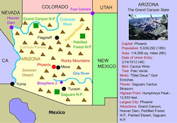
This interactive map allows students to click on Arizona's' cities, landforms, landmarks, and places of interest, to learn about their histories and impact on Arizona.


Make Your Own Arizona Map

Make Your Own Arizona Map!

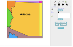
Use our colorful Maptivation program to make your own customized Arizona map. You can fill in Arizona and surrounding states with colors, add labels, landscapes, a key, and much more!


Arizona Interactive MAp

Arizona Fact or Fiction Printable Map

This activity requires students to analyze eight statements about the Arizona map and determine whether each is fact or fiction.


Arizona Label-me Map

Arizona Printable Label-me Map

This activity requires students to identify Arizona's surrounding states (and nation).


Arizona Label-me Map

Arizona Online Label-me Quiz

This activity requires students to identify Arizona's surrounding states and nation.


Arizona Blank Map

Arizona Outline Map

This is a Arizona outline map for students to label and color.


Southwestern States Label-meMap

Southwestern States Interactive Map

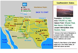
This interactive map allows students to learn all about the southwestern states, cities, landforms, landmarks, and places of interest by simply clicking on the points of the map.


New England Outline Map

Western States Label-me Map

This is a Western States outline map that students can color and label.


Western Ranges Map

Western Ranges Identification and Label-me Map

This activity describes the various mountain ranges in the western United States and requires students to identify the states in which they occur.


Arizona Printanble Activity Bundle

Arizona Printable Activity Bundle

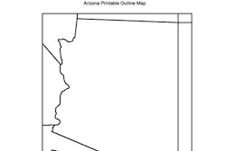
This packet contains 21 Arizona-based coloring pages and activities including state symbols, maps, welcome to Arizona sign, state quarter, maze, and numerous literacy activities featuring the Grand Canyon, Saguaro cactus and much more.