North Dakota Interactive and Label-me Maps

North Dakota Interactive Map

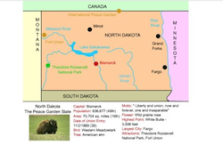
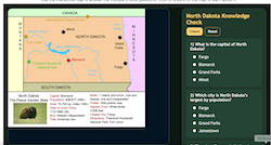
This interactive map allows students to click on North Dakota's cities, landforms, landmarks, and places of interest, to learn about their histories and impact on North Dakota.


Make Your Own North Dakota Map - Super Maptivating!

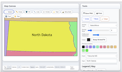
Use our colorful Super Maptivation program to make your own customized North Dakota map. You can fill in North Dakota and surrounding states with colors, add labels, landscapes, a key, and much more!


North Dakota Scavenger Hunt

North Dakota Interactive Scavenger Hunt

Use the interactive map to answer the multiple choice questions. Click on a point of the map to learn about it.


North Dakota Label-me Map

North Dakota Printable Label-me Map

This activity requires students to label North Dakota's surrounding states and major waterways.


North Dakota Outline Map

North Dakota Printable Outline Map

This map is perfect for labeling and coloring.


Midwestern States Label-meMap

Midwestern States Interactive Map

This interactive map allows students to learn all about the southwestern states, cities, landforms, landmarks, and places of interest by simply clicking on the points of the map.


Midwestern States Label-me Map

Midwestern States Online Label-me Map

This activity requires students to identify the midwestern states.


Midwestern States Label-me Map

Midwestern States Printable Label-me Map

This activity requires students to identify the midwestern states.


Missouri River

Missouri River States Printable Label-me Map

This activity requires students to label the Missouri River states.


Louisiana Purchase Map

Louisiana Purchase Label-me Map Printable

This activity requires students to label the states that would eventually be carved from the Louisiana Territory.


Louisiana Purchase Map

Louisiana Purchase Label-me Map Online

This activity requires students to label the states that would eventually be carved from the Louisiana Territory. It gives immediate feedback.