Illinois Interactive and Label-me Maps

Illinois Interactive Map

Interactive Illinois Map

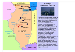
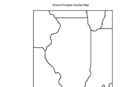
This interactive map allows students to click on Illinois's cities, landforms, landmarks, and places of interest, to learn about their histories and impact on Illinois.


Make Your Own Illinois Map

Make Your Own Illinois Map!

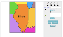
Use our colorful Maptivation program to make your own customized Illinois map. You can fill in Illinois and surrounding states with colors, add labels, landscapes, a key, and much more!


Make Your Own Illinois Map

Illinois Detailed Online Label-me Map

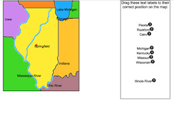
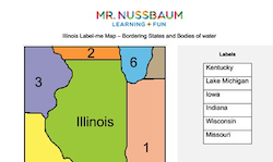
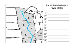
These online maps require students to drag and drop the cities, landmarks, rivers, and mountain ranges, to their correct places on each state. Students can get clues and immediate feedback. This Illinois map requires students to place 15 labels on the map including Chicago, Springfield, Mississippi River, Peoria, and much more.


Illinois Label-me Map

Illinois Printable Label-me Map

This activity requires students to label Illinois's surrounding states.


Illinois Label-me Map

Illinois Online Label-me Map

This activity requires students to label Illinois's surrounding states. The program gives immediate feedback.


Illinois Interactive Map

Illinois Printable Fact or Fiction Map

This activity requires students to analyze eight statements about the Illinois map and determine whether each is fact or fiction.


Illinois Blank Map

Illinois Printable Outline Map

This is a Illinois outline map for students to label and color.


Midwestern States Label-meMap

Midwestern States Interactive Map

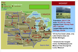
This interactive map allows students to learn all about the southwestern states, cities, landforms, landmarks, and places of interest by simply clicking on the points of the map.


Midwestern States Label-me Map

Midwestern States Online Label-me Map

This activity requires students to identify the midwestern states.


Midwestern States Label-me Map

Midwestern States Printable Label-me Map

This activity requires students to identify the midwestern states.


Mississippi River States Printable Label-me Map

This activity requires students to identify the Mississippi River states.


Mississippi River States Online Label-me Map

This activity requires students to identify the Mississippi River states. It give immediate feedback


Great Lakes Map

Great Lakes States Printable Label-me Map

This activity requires students to label the Great Lakes and to color or label the surrounding states.